
Potential Tropical Cyclone Six remains disorganized tonight, but deep convection continues to develop over the southwestern Gulf of Mexico.
The system is gradually becoming better organized and is expected to become a tropical storm by Monday. It is forecast to become a hurricane late Tuesday evening.
The National Hurricane Center has issued a tropical storm warning for extreme southern Texas from Port Mansfield south to the mouth of the Rio Grande.
A hurricane warning is expected for parts of the Louisiana and Upper Texas coast through Monday as the risk of life-threatening storm surge and hurricane-force winds continues to increase through midweek.

The latest forecasts suggest the storm will slowly move northwest over the next 24 hours before turning northeast and heading toward the Louisiana and Upper Texas coast by Wednesday. It’s difficult to say exactly where it will head because the storm hasn’t yet developed a clearly defined center, but the NHC is forecasting a hurricane that is expected to make landfall on the Louisiana coast Wednesday night.
FORECAST AND MODEL UPDATES
Several forecast models offer insight into the storm’s potential strength and path. The HWRF model predicts a 68-knot hurricane with a central pressure of 973 mb making landfall near Orange, Texas, around 7 p.m. CDT on Wednesday. Meanwhile, the HAFS-A model shows a stronger 80-knot hurricane with a central pressure of 970 mb making landfall near Pecan Island, Louisiana. The HAFS-B model is slightly weaker, forecasting a 60-knot system. The SHIPS model remains aggressive, indicating a high probability of rapid intensification, while the 18z ensembles for Europe have shifted eastward, indicating landfall further along the Louisiana coast.
The official NHC forecast shifts a little further east tonight. The official forecast brings tropical storm force winds to the southwest coast of Louisiana by midday Wednesday. Strong tropical storm force winds will reach the coast between 3 and 4 p.m. Wednesday. Landfall will occur between 6 and 7 p.m. Wednesday evening.
HURRICANE HUNTER FLIGHTS
The first Hurricane Hunter mission into potential Tropical Cyclone Six has been completed, and a second flight is currently underway. The data collected so far confirms that the system does not yet have a clearly defined center, but is continuing to organize. Five more reconnaissance flights are planned for tomorrow to provide more information on the structure and intensity of the storm.
With potential Tropical Cyclone Six likely to develop into a hurricane, everyone along the Texas and Louisiana coast should be prepared for potential impacts starting Tuesday night.
OTHER ATLANTIC SYSTEMS
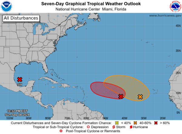
In addition to potential Tropical Cyclone Six, two systems are being monitored in the Atlantic east of the Lesser Antilles:
1. Central Tropical Atlantic (AL92)
As this low pressure system remains nearly stationary, a tropical depression is likely to form in the next few days.
* Chance of occurrence within 48 hours: 60 percent (medium)
* Formation probability within 7 days: 70 percent (high)
2. Eastern and Central Tropical Atlantic:
This widespread area of showers and thunderstorms is expected to interact with a tropical wave moving off the coast of Africa on Monday, with gradual development possible later in the week.
* Probability of occurrence within 48 hours: Almost 0 percent (low)
* Chance of occurrence within 7 days: 50 percent (medium)
category: Weather in Alabama, tropical
