
As Helene approaches the Big Bend region of Florida, a lot of moisture will be pulled northward, and parts of Alabama will face the threat of very heavy rainfall and flooding.
As you can see in this graphic, flood warnings are in effect not just for parts of our state, but for almost all of Georgia, and of course the warnings extend all the way down to the Florida Panhandle.

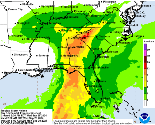
Here is the latest Day 1-5 WPC rainfall forecast graphic. In Alabama, there is a pretty clear boundary of where the heaviest rain will fall, and that boundary is based on the latest track of Helene. The highest rainfall amounts will be about east of I-65. Generally 4-6 inches, locally 8-10 inches depending on where some of the heavier bands form.
Details of the flood warning:
From NWS Birmingham:
…Flood Warning in effect from 1:00 p.m. CDT this afternoon through Friday
MORNING…
* WHAT…Flash floods caused by excessive rainfall are still
possible.
* WHERE…A portion of central Alabama, including the following
Counties, Calhoun, Coosa, Elmore, Etowah, Montgomery, St. Clair
and Talladega.
* WHEN…From 1:00 p.m. CDT this afternoon through Friday morning.
* IMPACTS…Excessive runoff can cause river flooding,
Streams, rivers and other low-lying and flood-prone areas.
* MORE DETAILS…
– In the afternoon, heavy rain will begin in some places,
on Thursday as Helene approaches the area.
Rainfall amounts of 4 to 8 inches are possible, with
locally up to 10 inches.
…Flood Warning remains in effect as of 1:00 p.m. CDT this afternoon.
UNTIL FRIDAY MORNING…
* WHAT…Flash floods caused by excessive rainfall are still
possible.
* WHERE…A portion of central Alabama, including the following
Barbour, Bullock, Chambers, Cherokee, Clay, Cleburne counties,
Lee, Macon, Pike, Randolph, Russell and Tallapoosa.
* WHEN…From 1:00 p.m. CDT this afternoon through Friday morning.
* IMPACTS…Excessive runoff can cause river flooding,
Streams, rivers and other low-lying and flood-prone areas.
* MORE DETAILS…
– In the afternoon, heavy rain will begin in some places,
on Thursday as Helene approaches the area.
Rainfall amounts of 4 to 8 inches are possible, with
locally up to 10 inches.
– http://www.weather.gov/safety/flood
category: Weather in Alabama, ALL POSTS, Severe Weather, Social Media
