

- Helene’s center is located near the Mexican Yucatan Peninsula.
- The storm is expected to develop into a hurricane during the course of Wednesday.
- Helene will make landfall in Florida on Thursday evening, but its effects will be felt long before then.
- Florida is threatened by life-threatening storm surges, destructive winds and torrential rain.
- By Friday, strong winds and heavy rain will reach deep inland in parts of the southeast.
Tropical Storm Helene is intensifying and is forecast to become a large, severe hurricane before hitting Florida’s Gulf Coast on Thursday with life-threatening storm surge, destructive winds and heavy rains.
The effects of Helene will not stop at the coast. Strong winds and torrential rain will also spread to parts of the southeast overnight from Thursday to Friday.
(MORE: Map tracking)
Where is it now: Helene’s center is located 45 miles east-northeast of Cozumel, Mexico, and is moving northwestward. Maximum sustained winds are 65 mph.
Rainfall from the storm is drenching parts of Mexico’s Yucatan province and western Cuba. Some widespread rainbands have at times extended as far north as southern Florida.

Current observations and warnings: A hurricane warning is in effect from the Big Bend in Florida to southwest Georgia, including Tallahassee. Storm surge warnings are in effect from Indian Pass south to Flamingo, including Tampa Bay and Charlotte Harbor.
Various tropical storm warnings and watches, as well as hurricane warnings, cover most other parts of Florida north to southern Georgia and southern South Carolina, as shown in the map below.
These warnings mean that hurricane, tropical storm, and storm surge conditions are either expected (warnings) or possible (advance warnings) in these areas within the next 36 to 48 hours.
Those in the warned areas should implement their hurricane plans and follow all advice from local emergency management authorities.

Here is the timeline:
- Wednesday: Helene’s center is closest to Cancun and Cozumel, bringing strong winds, storm surges, and heavy rains. Parts of western Cuba will also still see heavy rains and strong winds. Helene will eventually reach the southern Gulf of Mexico, strengthening and increasing in size. Some high surf and outer rainbands will reach parts of Florida, and tropical moisture intercepting a front could produce heavy, flooding rains in parts of the Tennessee Valley from Georgia to eastern Tennessee.
- Thursday: Helene is expected to reach its peak intensity in the eastern Gulf and then make landfall as a large, major hurricane somewhere along Florida’s Gulf Coast Thursday evening. Although computer forecast models suggest the most likely location for landfall is in Florida’s Big Bend or eastern Panhandle region, keep in mind that hurricane impacts (storm surge, wind, rain) often occur far from the center, especially in larger storms.
- Friday: Helene will move quickly northward through the Southeast toward the southern Appalachians and Ohio Valley with strong, potentially destructive wind gusts, torrential rain, and isolated tornadoes.
(Improve your forecast with our detailed hourly breakdown for the next 8 days – only available on our Premium Pro Experience.)

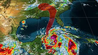
Current storm status and forecast path
(The red shaded area indicates the possible path of the tropical cyclone’s center. It is important to note that the impacts (particularly heavy rain, high surf, coastal flooding, winds) of a tropical cyclone typically extend beyond its forecast path.)
How strong could it be: Helene could reach hurricane intensity in the Gulf before making landfall.
That’s because heat content is a favorable component for intensification, and the map below shows that there is plenty of deep, warm water in the northwestern Caribbean Sea and parts of the Gulf of Mexico Ocean Current. In fact, the Gulf of Mexico’s heat content is at a record high for this time of year, according to tropical researcher Brian McNoldy of the University of Miami.
Therefore, Helene could rapidly strengthen until it reaches its peak intensity on Thursday.
Another factor to consider is wind shear. Wind shear typically limits or weakens tropical storms and hurricanes by either directing their circulation or blowing more thunderstorms away from their center.
The reduced wind shear should allow Helene to take full advantage of the deep, warm waters. There may be some increase in shear near landfall, but by then it is unlikely to have much of an impact on what is already a strong, large hurricane.
(For even more detailed weather tracking for your area, see our 15-minute detailed forecast Premium Pro Experience.)

Impact on the USA
Helene is forecast not only as a hurricane, but also as a large storm that could expand more quickly both as it approaches the coast and as it moves further inland. As we discussed in a previous article, this will affect the scope and severity of Helene’s impacts.
Storm surge
The National Hurricane Center’s storm surge forecast is shown in the map below. As you can see, storm surge flooding is expected across much of Florida’s Gulf Coast, including areas as far south as the Keys.
The highest storm surge is expected along and east of where Helene’s center makes landfall. At the moment, it looks like the Big Bend, Apalachee Bay, and Florida’s Nature Coast will be affected. Some flooding could 10 feet above the ground in these areas, especially if the highest storm surge arrives at high tide. For Cedar Key, this could be a record storm surge and easily several feet higher than the peak of Hurricane Idalia in August 2023 (6.84 feet).
Given the large wind field expected from Helene, significant storm surge flooding is also expected in the Tampa-St. Pete-Sarasota metropolitan areas, which could be greater than the flooding experienced by Hurricane Idalia over a year ago.
If you live near the coast, know your evacuation zone and follow all advice and instructions from local emergency services.

Storm surge forecast
(The combination of a dangerous storm surge and the high tide will cause normally dry areas near the coast to be inundated by rising waters moving inland from the coast.)
Winds
As previously mentioned, Helene will be a large and fast-moving storm both in the Gulf and as it moves inland, meaning its strong winds will cover a larger area than usual.
Not only are hurricane-force winds possible along a stretch of Florida’s Gulf Coast in areas under hurricane warnings, but these strong winds could also reach far inland into parts of northern Florida and far southern Georgia on Thursday evening. Downed trees and power outages could occur in these areas, and even building damage is possible.
Tropical storm force winds will spread quickly up the West Florida coast into the Panhandle in the areas shown below Thursday into Thursday night. These tropical storm force winds could then move well inland into much of Georgia, eastern Alabama, and parts of the Carolinas Thursday night into Friday. Some downed trees and power outages are quite possible in these areas.

NWS Peak Wind Threat
(This map from the National Weather Service shows the potentially strongest winds (likely gusts) that could occur. Areas colored red or purple have the greatest likelihood of hurricane-force winds, which could result in major tree damage, power outages, and at least some building damage. Areas colored yellow and orange could see at least some isolated downed trees and power outages.)
Precipitation
Helene will produce heavy rains generally along and east of its path this weekend, not only near the coast but also far inland to the southeast and into the Ohio Valley.
The heaviest rain is expected in parts of the Southeast Thursday into Friday, but some heavy rain bands are expected in parts of the Southeast, including metro Atlanta, well before Helene arrives on Wednesday. And some localized rain could linger in parts of the Ohio Valley and Florida into Saturday.
In the southeastern United States, rainfall amounts could range from 5 to 10 inches, with isolated areas up to 15 inches possible. This rainfall could lead to flash flooding and river flooding.
Higher elevations in the southern Appalachians are particularly vulnerable to flooding and possible landslides. NOAA’s Weather Prediction Center has issued a rare “high risk” flood warning for northeast Georgia into western North Carolina.
Increasingly moist soil in the southeast could also make it easier for Helene’s winds to topple trees.

Precipitation forecast
(Although not all of the rainfall shown above will come from this tropical system, they should be understood as rough estimates of where the heaviest rain may fall. Higher amounts may occur where bands or clusters of thunderstorms become entrenched over a period of several hours.)
Jonathan Erdman is a senior meteorologist at weather.com and has been covering national and international weather since 1996. Extreme and bizarre weather are his favorite topics. Contact him at X (formerly Twitter), Topics, on facebook. And Blue sky.
